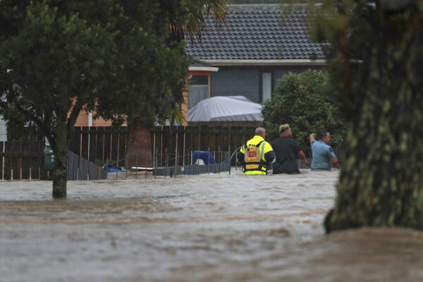
New Zealand on Friday issued a red alert in the Coromandel Peninsula and northern Gisborne as Tropical Cyclone Gabrielle approaches with heavy rain and gales, just two weeks after Auckland was hit with record rainfall.
The New Zealand MetService said the cyclone is currently located in the north Tasman Sea and is expected to reach the northern parts of New Zealand on Sunday before spreading southward on Tuesday.
“This is expected to be a widespread and significant weather event. Significant heavy rain and potentially damaging winds are forecast for many parts of northern and central New Zealand,” the alert states.
MetService said the Coromandel Peninsula and Gisborne north of Tolaga Bay may receive heavy rainfall in the range of 300 to 400 mm from Sunday to Tuesday, which could lead to “dangerous river conditions and significant flooding.”
🔴Red Warnings for Heavy Rain have been issued for the Coromandel Peninsula and Tairawhiti/Gisborne north of Tolaga Bay#CycloneGabrielle is expected to bring significant impacts to these areas
Keep up with the latest Severe Weather info at https://t.co/qHyE5zzql5 pic.twitter.com/7e3HCf71wg
— MetService (@MetService) February 11, 2023
“Slips and floodwaters are likely to disrupt travel, making some roads impassable and possibly isolating communities. Power outages are also very likely,” it stated.
Orange heavy rain warnings were also issued for Northland, north Auckland, and Hawke’s Bay for 24 hours. MetService said the alert period could be extended and raised to a red level if the heavy rain persists.
“Severe gales, with gusts reaching 120 to 130 [kilometers per hour], or possibly higher from Monday depending on Cyclone Gabrielle’s track. Winds should initially be east to southeast, then are expected to turn south to southwest later on Monday or early Tuesday,” it noted.
Emergency management minister Kieran McAnulty on Friday urged New Zealanders to plan and prepare for the severe weather and warned them to stay alert due to the cyclone’s changing trajectory.
“The government is taking this very seriously and is ready to respond to keep people safe and support impacted communities,” McAnulty said, according to Sky News.
“We’re using the next few days to get ready, and with clear weather today and Saturday it’s a good time to make sure you and your family are prepared,” he added.
New Zealand’s ‘Most Serious Storm’
New Zealand weather forecaster WeatherWatch.co.nz said the cyclone, which will most likely become a Category 3 cyclone this weekend, will reach the country between Sunday and Tuesday.
Category 3 storms have winds of 119-157 kilometers per hour, with gusts up to 224 kilometers per hour.
“If this current modelling comes true, this will likely be the most serious storm to impact New Zealand this century—especially with Auckland being in the mix for a potential direct hit,” it said on Wednesday.
It added that the potential weather event would be concerning even if had Auckland not recently experienced serious flooding.

Earlier on Jan. 27, a state of emergency was declared in Auckland as the region experienced widespread damage from flooding and torrential rains. At least four people died in flash floods and landslides that hit the country’s largest city.
Flights in and out of Auckland Airport were delayed or canceled, and all Auckland schools were closed until Feb. 7. New Zealand Prime Minister Chris Hipkins said that around 350 people were in need of emergency accommodation following the flash floods.
The north of New Zealand’s North Island is receiving more rain than normal due to the La Nina weather event.
The National Institute of Water and Atmospheric Research (NIWA) said Auckland has already recorded more than eight times its average January rainfall and 40 percent of its annual average rainfall.
Roughly one cyclone affects New Zealand each year. However, MetService said the characteristics and structure of any tropical cyclone will change dramatically by the time it reaches New Zealand, and it will almost certainly be re-classified as an ex-tropical cyclone.
“Re-classification as an ex-tropical cyclone does not necessarily mean the system has weakened,” MetService added.
Reuters contributed to this report.

